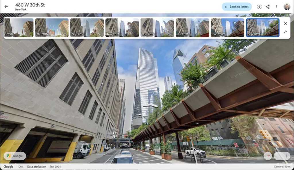
In a remarkable celebration of its 20th anniversary, Google Earth has unveiled a captivating new feature that enables users to rewind time and access historical imagery within the app. This exciting functionality allows users to explore older versions of familiar locations, showcasing the transformations that various areas have undergone over the years. This development marks a significant enhancement in how we visualize our world and understand its evolution.
Historical Street View Images
With the introduction of historical Street View images, Google Earth allows its users to dive into the past and witness the changes that have taken place in specific locations. This feature is particularly intriguing as it enables users to scroll through older images, offering a compelling perspective on urban development, environmental changes, and the impact of time on geography. Previously, access to historical imagery was limited to Google Maps, but the integration into Google Earth now provides a more immersive experience for users.
The feature is relatively straightforward to use. By navigating to a chosen location and selecting the time-travel icon, users can seamlessly transition through different dates, observing how a location has evolved over time. This capability not only sparks curiosity but also serves educational purposes, particularly for students and researchers interested in geography or urban planning.
Previous Enhancements and Future Features
This addition to Google Earth is not an isolated incident; it follows last year’s major update, which introduced historical satellite and aerial photos to users, previously exclusive to the Earth Pro desktop application. These aerial images allow users to analyze changes in landscape and infrastructure from a broader perspective, complementing the detailed street-level views provided by the historical Street View feature.
Moreover, Google has announced plans to roll out an upcoming feature designed to provide professional users with AI-based insights about Earth. This new capability could include valuable data on tree canopy cover, soil temperature, and possibly other environmental factors, rendering Google Earth not just a visual tool but also a resource for environmental analysis and research.
Impact on Users and the Environment
The ability to view historical data through Google Earth establishes a robust platform for understanding geographical and environmental changes over time. Urban planners, conservationists, and environmental researchers can leverage this information to make informed decisions and develop strategies for sustainable development. According to a report from the Statista, Google Earth reached a staggering 1 billion downloads, indicating a vast user base eager to explore its capabilities.
This innovative feature can also engage casual users, sparking interest in the environment and history. As individuals explore their neighborhoods or favorite vacation spots, they can reflect on how cities and landscapes have evolved, potentially fostering a deeper connection to their environment.
Community and Industry Response
The announcement has generated significant excitement within both the tech industry and user communities. Many users have taken to social media to share their experiences and reflect on their nostalgia as they revisit memories tied to specific locations. This sentiment was echoed by internet users expressing enthusiasm about the potential for storytelling through imagery, illustrating how communities can recount their unique histories through Google Earth.
Moreover, environmental organizations have expressed interest in the potential applications of the AI-based insights, anticipating how these tools can enhance their work in tracking deforestation, urban expansion, and climate change indicators. As highlighted by Google’s official blog, this integration of AI into the user experience could transform Google Earth into a vital tool for environmental monitoring and awareness.
Quick Reference Table
| Feature | Description |
|---|---|
| Historical Street View | Access to older versions of locations to observe changes over time. |
| Historical Satellite Images | Aerial views of locations showing development and environmental changes. |
| AI Insights (Upcoming) | AI-driven data on environmental factors like tree cover and soil temperature. |
| Global Users | 1 billion downloads worldwide, illustrating Google Earth’s popularity. |
This evolution of Google Earth not only celebrates a milestone for the application but also paves the way for a deeper understanding of our world. With enhanced tools for exploring our planet’s history and future, Google Earth emerges as a cornerstone for education, research, and environmental awareness in the digital age.

